Norvald Bjergene, DNMI
There are many demands made of freighters in the market today - demands for swifter delivery and greater precision, less damage to cargo, lower rates, reduced discharges to the environment and larger profits for the owners. In order to meet these demands, freighters must be able to withstand the prevailing weather and sea conditions.
Sea Star is no substitute for human knowledge and powers of judgement. The program bases the proposed route on the captain's own assessment of the vessel's general conditions and his preferences in terms of route and timing. The captain may also specify parts of the route, leaving the rest to be determined by Sea Star. When communicating with the shipping company, Sea Star provides both parties with identical, comprehensive details of weather and sea conditions and relevant routes. By combining meteorological and oceanographic models with nautical know how and experience, Sea Star provides the very best basis for making the right decisions in a dynamic and demanding industry.
Sea Star Ship Weather Routing System consists of a computerized calculation program, a computerized model of the operational properties of each vessel and regularly updated prognoses of weather and sea conditions.
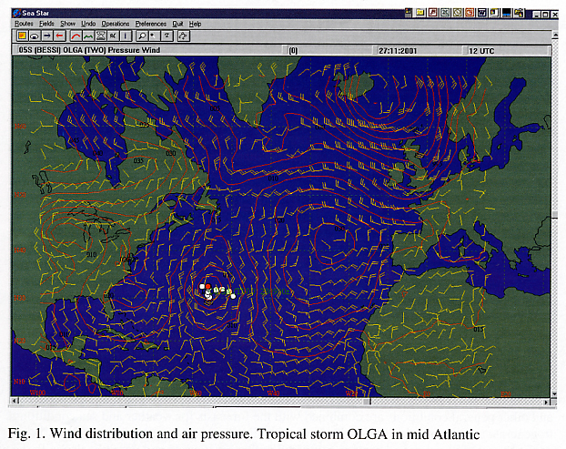
The forecasts cover wind strength and direction, atmospheric pressure, currents, wave heights, swell, wave direction and speed and warnings of tropical storms.
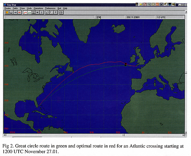
The computerized model of the vessel, the captain's assessment of draught, engine capacity and other general conditions are combined with the forecasts for weather and sea conditions to generate a recommended route with lowest possible fuel consumption in the calmest possible seas. The suggested route is compared with a great circle and possibly also with the captain's own preferred route.
The recommended route is presented as charts and in tabular form, showing position, time, speed fuel consumption and estimated time of arrival.
The user can specify waypoints en route and let Sea Star determine the rest of the route. Sea Star can also recommend a new route in connection with tropical storms.
The Sea Star Ship Optimal Weather Routeing is a product from DNMI- Norwegian
Meteorological Institute which also provides the weather and sea state
forecasts used in the programme's calculations. Computerized models of
the individual vessel's properties are produced by MARINTEK, the Norwegian
Marine Technology Research Institute. Sea Star is a window-based application,
which can be installed on all modern PCs. Weather data, can be delivered
via e-mail or other types of data transmissions.
A new version of Sea Star, the C-Star is under development in cooperation
with C-Map Norway. This version, combined with and on the basis of electronic
navigational chart will be released by the beginning of 2002.